August 6, 2012

Inle Lake (March 8-March 11, 2012)

As famous as Bagan is for its history, Inle Lake is famous for its natural beauty and people. The 116 square kilometer lake is home to the Intha people, who continue to live in small stilted communities along the lake’s shore. They make their living from the lake by fishing, gathering seaweed, making fabrics from lotus flowers, and gardening. The men row distinctively across the lake, standing at the stern and paddling with one leg wrapped around an oar as they fish with large, hand-woven baskets. It is a way of life we can only imagine is fast-declining, but is still thriving here. 

As an introduction to the area we took a boat tour around the lake. While the trip was a little touristy, we enjoyed visiting a nearby market, seeing several of the handicraft shops (including the cigarette rollers and lotus weavers), chatting with the other travelers in our boat, getting up close to fishermen, paddling through stilt houses, and receiving enthusiastic waves from locals busily paddling or motoring across the lake. It was a wonderful way to see the area and a great way to spend Nora’s birthday! That evening we had dinner with a German couple from our boat tour at a local restaurant/bar. It was a fun birthday dinner for Nora, made better by running into two Americans traveling around Myanmar together, dressed as Mario and Luigi. We aren’t sure what the locals were making of their costumes and facial hair, but we thought it was pretty funny.

On our second day here we went on a walk outside of town, through some small villages. The people here, as everywhere in rural Myanmar, were incredibly friendly. Though we had a language barrier, people happily greeted us with a friendly “mingalaba!” and a wave. Our final destination was a winery in the hills where we did a tasting of some of the local wine. It was not the best wine we’d ever had, but it was a fun treat, nonetheless.

The town of Nyaungshwe, where we stayed, had an interesting local market that we liked to browse. It was bustling with locals and full of stands for traditional skirts (longgi), woven shopping bags, produce and meat, and everything your average Burmese person might need. It was also home to some great, cheap food stalls and we ate here more than once, sampling grilled fish from the lake, the Burmese take on Indian roti, and “husband and wife cakes” (mote lin mayar). While we were here the town experienced a terrible fire that took out about half of a block near downtown. It was a chaotic scene with hundreds of bystanders clogging the streets and locals fighting the fire with garden hoses and plastic buckets full of water. By the time the “fire truck” arrived and made its way through the crowds, the fire had nearly burned itself out.Though the mood of the town was decisively nervous, it was amazing to watch locals come together to help put out the fire as quickly as possible and then begin demolishing and rebuilding the next day.

Click on the photo below for our Inle Lake photo album.

August 5, 2012

Bagan (March 4-March 8, 2012)

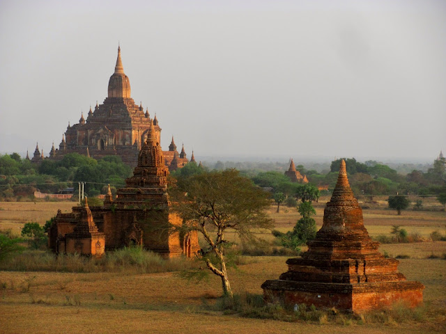
Bagan is easily one of the most magnificent sites in all of southeast Asia. In the 11th century, King Anawrahta began building the capital of his empire on the plains along the Irrawaddy River, and during this period, over 10,000 stupas and temples are believed to have been constructed here. Over two-hundred years later, Bagan fell into decline and disuse. What remains now are the ruins of over two thousand beautiful brick stupas and stone temples scattered across 42 square kilometers. Though the temples and stupas are incredibly beautiful themselves, it is the panoramic views of the unbelievable landscape from the top of any of the tallest temples that really makes Bagan so amazing.

We explored the site by bicycle for two days, riding along dirt trails to visit some of the more obscure temples, and riding in the dust clouds of large tourist buses at the more popular ones. Some of the temples have incredible frescoed interiors while others have intricately carved reliefs decorating their exterior. Some of our favorites included Thatbyinnyu and Dhammayangyi Temples (Bagan’s tallest and biggest overall temples, respectively), and Ananda Temple which was most spectacular at sunset when its golden pagoda seemed to glow. No two temples or pagodas are alike and they are all amazing, which is what makes Bagan such an incredibly special place and one of our favorite destinations of the entire year.

Click on the photo below for our Bagan photo album.

August 1, 2012

Mandalay (March 2-March 4, 2012)

From Pyin Oo Lwin we headed west to Mandalay, Myanmar’s second largest city. The city is fairly large, with about one million residents, and is located on the Irrawaddy River. Unfortunately, the city’s primary tourist attractions are all run by the country’s military dictatorship, so all entrance fees collected support the regime. We decided we didn’t want to contribute financially to the government more than we had to, so we skipped the city’s main sites, opting instead to do a walking tour that led us to several pretty pagodas and through the extensive markets.

One evening we also attended a “Moustache Brothers” comedy show. The troupe of three real brothers has been performing for decades and their anti-government satire has cost them dearly: two of the brothers, Par Par Lay and Lu Zaw, spent six years doing hard labor after a performance at Ang Sang Suu Kyi’s home in 1996 and Par Par Lay was re-arrested in 2007. Since his release, the government has backed off a little and seems to look the other way as the brothers perform nightly shows in their garage (but the audience is foreigners only). It was a fun mix of comedy and traditional Burmese dance, but it was their unflinching commitment to speaking out against their oppressive government that truly left us awe-struck.

From Mandalay, we jumped aboard a ferry for a scenic, eight-hour journey down the Irrawaddy River to Bagan. Unfortunately, the dry season meant the rivers were running a bit low, and despite the efforts of the two depthfinders perched at the front of the ferry (two guys with long poles), we kept running up on sandbars. Usually, we were able to move off of them fairly quickly, but one particular sandbar toward the end of our journey kept us stuck for over two hours. Fourteen hours later, we arrived in Bagan.

Click on the photo below to view our Mandalay photo album.

July 31, 2012

Hsipaw and Pyin Oo Lwin (February 29-March 2, 2012)

We reached the small town of Hsipaw (population 15,000), in Northeastern Myanmar, by a long, bumpy, overnight bus trip. Our seats at the back of the bus were so uncomfortable that Patrick ended up stretching out on the dirty aisle floor just to catch some shuteye. Located in Shan State and surrounded by mountains, it is a popular destination for trekking and visiting small, traditional villages. Unfortunately, February and March are some of the driest and hottest months of the year here, and the time of year when locals use “swidden” (aka slash and burn) farming techniques to ready their fields for next season’s crops. With no rain the air was smoky and dusty, and, as a result, we decided not to do any extended trekking here. Instead, we spent a full day hiking around the town, visiting several traditional villages and an area known as “Little Bagan” because of its many stupa ruins. While the area was very pretty, the friendly locals were the highlight, waving and shouting out a friendly “mingalaba!” greeting as we passed.

From Hsipaw we braved the Burmese rail system, little modernized since the British built it in the late 19th century, and headed to Pyin Oo Lwin. The train ride was one-of-a kind. Our car rocked heavily from side to side for much of the ride, so much so that our backpacks could not stay on the luggage racks above our head. As we approached the Goteik Viaduct, a bridge largely left untouched since it was completed in 1900, we slowed to a crawl in order not to put too much stress on the old bridge. Though long and slow (it took us 10 hours to travel about 85 miles), the ride was pleasant and interesting. At each stop women would come to the train windows with huge trays of food balanced on their heads offering up everything from grilled chicken to baskets of strawberries. On board, Patrick made friends with a Burmese family by taking photos of the daughters and showing them the digital image as they giggled and signaled that they wanted him to take another. At one of the stops their mother bought two baskets of strawberries from a woman on the platform and gave one to each of us, though we tried to decline, she insisted. It was a very sweet gesture and we were touched.

Pyin Oo Lwin, at 3,500 ft elevation, was nice for its cooler temperatures and old British architecture (it was once the summer capital/”hill station” of British Burma). The city is currently home to two military academies and the streets were filled with Burmese soldiers on their day off. We only spent a morning here before moving on to Mandalay but it was a pretty place to pass some time. The streets are mostly unpaved, and horse-drawn carriages kick up dust as they pass. The architecture is predominately British colonial, though not much has been done to preserve the buildings so they have a decidedly run-down look to them. Before leaving we walked through the city’s bustling market, stocking up on several items made from strawberries, the area’s agricultural claim-to-fame, including wine and jam made from the local berries.

Click on the photo below to view our Hsipaw and Pyin Oo Lwin photo album.

July 25, 2012

Yangon (February 26-February 28 and March 12-March 14, 2012)

Before deciding to visit Myanmar we did quite a bit of research into the potential impact of a visit to this military dictatorship. Starting in the mid-1990s, anti-government activists both inside and outside of Myanmar called for a tourism boycott of the country. Now, however, as things seem to slowly open up in this isolated country, leaders generally encourage outsiders to visit. Aung San Suu Kyi herself, one of the most fiercely anti-government activists in the country, was once in favor of the boycott, but now supports informed, responsible tourism. With this in mind, we were leaning toward visiting this less-visited country. When we found out Patrick’s friend Brett was living in Yangon, our decision was made, and we booked a flight from Kuala Lumpur.

Yangon (formerly known as Rangoon), a sprawling city of 5 million, was the capital of Myanmar until 2005 when the government decided to build a new capital city further north. We were here twice, capping our three weeks in Myanmar. The city is a little grimy and chaotic, but no more so than many cities we visited on the Indian sub-continent, and we liked the lively international feel of the city. Our first time through we went straight to the guesthouse where Brett was staying. After a little catching up we headed to a fundraiser put on by some of Brett’s students benefiting war-torn Kachin communities in northern Myanmar. Through music, art, and comedy young Burmese were standing up for their countrymen. Though mild by international standards, their protests seemed quite brave in a country with a government that has little tolerance for dissent.

We spent our next day visiting the nearby town of Bago, the former capital of the Mon people of southern Myanmar, and its numerous pagodas and temples with Brett. Shwethalyaung, the long reclining Buddha with jeweled feet and Shwemawdaw Paya, an outstanding golden stupa, were some of our favorites.
On our second time through Yangon we did most of our sightseeing. The highlight of Yangon is Shwedagon Paya, which we visited with an entertaining guide. At the center of the complex is the iconic stupa, covered in gold leaf and partially encrusted in diamonds and other gems. The stupa is impressive up close and adds a beautiful silhouette to Yangon’s skyline. The stupa is surrounded by 82 other temples, shrines, and pagodas with lots of hidden gems we wouldn’t have noticed without our guide, “Mr. Kind.”

While in Yangon we also visited Kandawgyi Lake with some of Brett’s students who happily talked to us about their lives as students. We also visited Sule paya, the gold stupa in the heart of downtown Yangon, and Bogyoke Aung San Market, a market full of Burmese souvenirs and everyday household items dedicated to Aung San Suu Kyi’s father, the leader of the movement that gained Burmese independence from the British Empire in 1948. In the evenings, Brett took us to some of his favorite restaurants where we ate great Burmese and Indian food, and bars where we drank the local beer, appropriately named “Myanmar,” among friendly, if often very-underage, Burmese people. It was really great to see Brett and a relief to have an expert to introduce the country to us, including its sometimes strange customs (for example money-changing, which is traded on a black market, involves dodging swarms of street hustlers, and knowing where you can negotiate the best rate!).

Click on the photo below  for our Yangon photo album.

July 20, 2012

Kuala Lumpur (February 20-February 22 and February 24-February 26, 2012)

We had already passed through Kuala Lumpur (better known as “KL”) twice, spending a night here when we arrived in Malaysia and spending two more nights on the town with David on our way to Melaka, but we didn’t really explore KL until the end of our Malaysia visit. Our first impressions were just how modern and clean the city felt, especially after three months in Nepal and India, and that the city wasn’t as big as we expected. Pictures of the city featuring the iconic Petronas towers, the Menara KL tower, and other skyscrapers leave the impression that the city is a metropolis, much bigger than the city of one million residents that it actually is.

KL is also cosmopolitan. The extensive and integrated transit system (with light rail, monorail, and trains) is quick and efficient, and most of the buildings are modern (no doubt due to the fact that the city has only come into its own over the last 20 years). The numerous malls, western chain stores, and fast food outlets offer a decent facsimile of many U.S. cities, however, step around the corner and you might find a Chinese street food market, a fruit vendor selling stinky durian, or an Indian trying to lure you into his buffet restaurant. In this, we could really feel the melting pot of Malaysian society, where Indian and Chinese descended Malaysians coexist with the Muslim Malays. It was not uncommon to see an Indian parade blocking the traffic outside a Hindu temple, while only a few blocks away, in a shopping district, modestly dressed Malay women in headscarves are crossing paths with Chinese women in short-shorts and skimpy tops.

While exploring KL, we were underwhelmed by Chinatown, visited Merdeka Square, admired the Petronas Towers and enjoyed the A.C. of the huge mall at their base, and were awed by the views from the observation deck at Menara KL tower. We had a great time with our friends in this city and it made for a nice welcome to Southeast Asia.

Click on the photo below for our Kuala Lumpur photo album.

May 29, 2012

Melaka (February 22-February 24, 2012)

Melaka, in southern Malaysia, is another of the British Straits Settlements and, like Georgetown in Penang, it has strong colonial and Chinese influences. We explored the city by foot, as usual, and found that the rich history of Melaka was present everywhere we looked. The bright pink buildings of the 17th century Stadthuys (Dutch Town Square), the 16th century Portuguese St. Paul’s Cathedral sitting atop Bukit St. Paul (St. Pauls Hill), and the 17th century Cheng Hoon Teng temple, as well as the colorfully decorated rickshaws we saw all around town all spoke to the rich cultural history of this city. Melaka’s famous cuisine also reflects the city’s diverse history, and we sampled our fair share of the city’s specialties during our two days. Highlights were dim sum breakfasts, laksa (thick curry noodle soup), celup (a satay-flavored hot pot), popiah (a local take on spring rolls), the best cendol we had in Malaysia, and several Nonya (descendents of 15th and 16th century Chinese immigrants, as opposed to more recent Chinese immigrants) dishes including pork and rice dumplings steamed in banana leaves and pineapple tarts.

Click on the photo below for our Melaka photo album.

May 17, 2012

Pulau Langkawi (February 13-February 19, 2012)

Just a short hop south of the Thailand border, Pulau Langkawi offered some welcome relief from the heat and humidity of mainland Malaysia. We spent a full week here, only leaving the tiny beach village of Pantai Cenang twice – once to go on an “island-hopping” tour and another time to tour the island by scooter. The island-hopping tour gave us our first glimpses of the iconic karst landscapes of Southeast Asia, and also took us to the Pulau Dayang Bunting (home to Pregnant Maiden Lake), which is occupied by terrorizing monkeys that tried to steal Patrick’s wallet. Otherwise, we relaxed on the beach and swam, watched DVD’s from the huge collection at our guesthouse, or played free games of pool at the guesthouse bar. By surprise, we also ran into Thunder here (one of David’s friends that we’d met in Taiping), and we spent two fun evenings on the beach before he headed back to the mainland.

Click on the photo below for our Pulau Langkawi photo album.

May 14, 2012

Pulau Penang (February 10-February 13, 2012)

From Taiping it was a short trip to the island of Penang (Malay: Pulau Penang). Situated in a strategic location just off the west coast of Malaysia in the Straits of Melaka, Pulau Penang was the first capital of the British Straits Settlements, and the colonial influence is strong in the islands’ main city, Georgetown. About the same size as Taiping (our previous stop), Georgetown is firmly on the backpacker circuit. As such, it offers the usual assortment of guesthouses, bars and restaurants catering to tourists, and souvenir shops – a stark contrast to untouristy Taiping.

In Georgetown, and Pulau Penang in general, we really started to see the interesting cultural blend that makes up Malaysian society. Chinese and Indian descendants, several generations removed from their homelands, coexist with the predominantly Muslim Malays. Every city seems to have a Chinatown and a Little India, while the Malays still dominate the culture. A random walk through town would generally pass a handful of Chinese temples, a few Hindu temples, and, of course, some mosques.

We spent two days on Pulau Penang. On the first, we explored the town on foot, visiting the impressive Khoo Kongsi (the city’s first “clan house”), as well as a number of small Chinese and Hindu temples and running into an interesting fair at Padang Park along the waterfront. Within a few minutes, we realized that the hundreds of vendor booths each represented some faction of Malaysia’s military or police, and this was a job fair of sorts. We had learned in Taiping that the ubiquitous, huge, blue-and-white apartment blocks that we had seen everywhere were police housing. We hadn’t been able to believe that a small city like Taiping could support such a large police force, but the hundreds or thousands of high school age students at this fair suggested that it must be one of the biggest employers in Malaysia. The fair even featured a dramatic police demonstration. The central area of the park was cleared and two SUV’s filled with “bad guys” roared into the park, swiftly followed by police cars with sirens blaring. As the cars sped in circles, a “shoot-out” started, and the police got the vehicles stopped and dragged the “criminals” to the ground. Suddenly, two helicopter swooped low over the park, a gunman mounted on the side, and a rope dropped out, quickly followed by a swat team to provide backup. As quickly as it started, the “show” was over, and a marching band took to the field playing patriotic sounding tunes. It was quite the show of force.

Our second day, we rented a scooter and headed a little further afield. Besides just getting lost in the winding roads in the hills, the highlight of the day came when we visited Kek Lok Si temple, a huge Buddhist temple complex set into the side of a hill with impressive views back towards Georgetown. That night, back in town, we tried the night food market, sampling a variety of foods, both new and familiar, including chicken satay and rojak (fruit salad in sweet tamarind and palm sugar sauce garnished with crushed peanuts). The next morning saw us jump onto a ferry in search of sun, sand, and a little “R-and-R” on Pulau Langkawi.

Click on the photo below for our Pulau Penang photo album.

May 13, 2012

Taiping (February 3-February 10 and February 19-February 20, 2012)

Even in the early stages of planning this trip, when almost nothing was certain, we knew Malaysia would be one of our destinations. Nora’s good friend from college, David, lives here and we were really looking forward to visiting him. David lives in Taiping with his girlfriend Erin, in a big, four bedroom, two-story house. The size of the house is important because it happened that on the exact same day we landed in Kuala Lumpur, totally by coincidence, three other sets of David’s friends also arrived in Kuala Lumpur to visit him. Matt and Trina had flown from the Philippines for their honeymoon, Thunder was visiting from South Korea, and globe-trotters Kevin and Florence brought their son Tyler from Japan. We spent one late night on Changkat Bukit Bintang (a popular street packed with bars and restaurants) in Kuala Lumpur before heading to Taiping the next afternoon. It was a full house, but fortunately it was a really fun group and we enjoyed several days of home cooked meals, walks around the lake, and drinking Carlsberg beers. We even got up at early one morning to drink Bloody Marys and watch the Super Bowl.

We also spent a fascinating afternoon visiting a local Hindu temple for the holiday of Thaipusam. We weren’t always sure what was going on, but the locals happily invited us to watch and participate in the ceremony. They burned palm fronds and beat drums, and at one point invited us to join them as they poured milk over a Hindu shrine. Throughout, those that spoke some English tried to explain things or at least told us where to stand and what to do. They even invited us to eat with them at the end of the festivities. We were really touched by how welcoming everyone was to our big group of outsiders!

After the other guests left we spent two more nights in Taiping. While David and Erin worked, we borrowed their bicycles and explored Taiping. A quiet city of 200,000, Taiping was a 19th century tin mining center and then a seat of British colonialism. By bicycle we explored the colonial old town and its famous “Tamin Tasik Taiping” (lake gardens), 62 hectares of pretty lakes and green parks, set in an abandoned tin mine dating from 1880. We also visited the zoo here, which had a surprisingly good collection of animals (though we were a little suspicious about how secure the animals were in their enclosures). The food in Taiping was tasty too and we tried mee goring (fried noodles), umbra (umbra juice with sour plums), and cendol (sweet rice-flour noodles mixed with shaved ice, coconut milk, red beans, and brown sugar syrup). The highlight of these two days, though, was spending the evenings with David and Erin, cooking and catching up.

Unfortunately, Erin got sick and missed our last home cooked meal together. Fortunately, though, after visiting Penang and Langkawi, we passed through Taiping again (David and Erin were so kind as to come pick us up from the ferry), and we spent one more night here, capping our time in Taiping by lighting and releasing paper lanterns. The next day David drove us to Kuala Lumpur. Along the way, we stopped at Bethany Home, a center for disabled children in Teluk Intan, where Mr. Jayasingh gave us an informative tour and we learned about the life and tribulations of the disabled in Malaysia. It was uplifting to see such compassion from their local and foreign staff, but it is a major uphill battle in a place where disabilities are poorly understood and mental disability, in particular, often presents a great social stigma for an entire family.

Click on the photo below for our Taiping photo album.

May 6, 2012

Kandy (January 30-February 3, 2012)

Kandy is Sri Lanka’s second largest city, located about sixty miles east of the capital and largest city, Colombo. The city is built around a pretty manmade lake (built in 1807) with a beautiful temple and palace complex on its shores. Once we arrived here we were a little wiped out and our time here was fairly relaxed. We enjoyed walking around the lake, and visiting the devales, temples devoted to the four gods (Pattini, Natha, Vishnu, and Kataragama) who protect the city. We also visited the former Royal Palace complex, but skipped the city’s most famous site, the Temple of the Tooth. The temple houses an important Sri Lankan religious relic, a tooth supposedly saved from Buddha’s cremation fire. Though the tooth itself is rarely publicly displayed these days, it is supposedly about three inches long and therefore not likely a human tooth. After Kandy we spent one final night in the town of Negombo, near the airport, before catching our early morning flight to Malaysia.

Click on the photo below for our Kandy photo album.

May 1, 2012

Adam’s Peak (January 28-January 30, 2012)

Our train ride from Ella took us to Hatton, where we caught a crowded local bus to Dalhousie. Though only about 30 kilometers in distance, the up-and-down, winding road took over two hours to navigate and left few of the locals sick to their stomachs. Dalhousie is a tiny town that mostly exists to support pilgrims and tourists attempting to climb Adam’s Peak (Sri Pada).

Buddhists believe that an imprint on the rock at the summit is the footprint of Buddha, and they have been making pilgrimages here for over a thousand years. Other religions, however, have also laid claim to this mountain. Some Hindus claim it’s the footprint of Shiva, and some Muslims believe it is Adam’s first footprint after being cast out of Eden. Adam’s Peak is a very popular pilgrimage for Sri Lankan Buddhists (some return every year), but believers of all faiths make the trek up to the summit to view the “footprint” and admire the amazing sunrise view.

The peak, though not that high at 2,243m (7,359 ft), is a daunting sight from town. We started out at 2:30 a.m. with two other travelers we befriended, Carole from Switzerland (who we met on the railroad tracks in Ella) and Mark from Ireland, in order to reach the top by sunrise. The trail begins fairly easily, passing a mind-numbing number of shops open at this early hour to sell snacks, tea, and all kinds of unnecessary knick-knacks to pilgrims. Soon, however, the trail becomes stairs that head, more or less, directly up the mountain. Because it was a Saturday night (technically Sunday morning) the trail was packed with locals making the pilgrimage. We saw newborns being carried up in their parents’ arms and great-grandmothers being supported up by sons and grandchildren. Some people stopped along the way to sleep on the stairs, often creating a backlog along the trail. About two and a half hours into the hike, with what we thought was about a half-hour left to climb, we came to a near standstill because there were so many people on the trail that no one could go up any further. For the next two hours we moved at a snail’s pace, moving only if others ahead of us began descending. Despite giving ourselves four hours to complete the seven kilometer hike, we didn’t reach the top in time for sunrise, but did have a wonderful view from the steps just below. It may have been for the best, though, since the summit was insanely crowded and actually had more obstructions of the view.

As soon as the sun had completely risen, there was a mass exodus down the mountain and the summit cleared enough to do a quick tour to get the 360-degree view. Within twenty minutes the crowd had almost totally dispersed, but we skipped the footprint, which had a very long line, and headed back down. We flew down, passing many of the older Sri Lankans who struggled down the often very steep stairs. Breakfast was waiting for us at our hotel, and we spent the rest of the day relaxing on our porch listening to the sound of the passing creek and admiring the lush green garden, happy to have some respite from those early morning crowds. That evening we had a nice dinner and too many Lion beers with Carol and Mark. It was a fun way to say goodbye to our new friends.

Click on the photo below for our Adam's Peak photo album.

April 30, 2012

Ella (January 25-January 28, 2012)

The tiny, touristy town of Ella is in Sri Lanka’s hill country. It’s a lush area, covered in tropical forests and beautiful green tea plantations, and the first place we had been in a while where we needed to wear jeans at night. The town itself doesn’t have much to offer besides some tasty restaurants (where we ate more rice and curry and tried our first “kottu roti:” rotis chopped up and stir fried). The main reason the town attracts tourists is its hiking opportunities and wonderful views down the deep valley, toward the plains below, known as the Ella Gap.

The first hike we did was to a peak called Ella Rock on the southwest side of the Ella Gap. The trail takes you along the railroad tracks (with only six very slow moving trains per day this is a surprisingly safe route) and through tea plantations and agricultural fields before it starts steeply up the mountain to a great view point. On our way back down, Patrick stopped to help some very appreciative locals who had gotten their truck stuck in the mud (and got covered in mud in the process). We also hiked through more tea plantations to Little Adam’s Peak to another wonderful view point. On our last morning in Ella, we visited the Halpewatte Tea Plantation where we took a very interesting factory tour. The process of turning newly picked tea leaves into black tea is surprisingly simple and straightforward, but not something either of us knew anything about. We loved the antiquated building and machinery and the smell of tea that wafted about the building.

From Ella we took a wonderfully scenic train ride, through mountains and tea plantations, often only just below the clouds. The train was crowded with Sri Lankans doing weekend traveling and we couldn’t get seats so instead we snagged a spot in a doorway which proved to be a better place for unobstructed views of the scenery. The train itself was old and slow (the entire Sri Lanka train system is little changed since the British built it in the late 19th century), moving at about 20 kilometers per hour, but it was a fun experience.

Click on the photo below for our Ella photo album.

April 29, 2012

Unawatuna (January 20-January 25, 2012)

We hadn’t originally planned on visiting Sri Lanka, but after several people recommended it we decided to add a two-week stop over here on our way from India to Malaysia. After arriving at the airport, we moved quickly through the congestion of Colombo and jumped on a bus headed to the south coast, where we stopped in a beach town called Unawatuna.

The beach at Unawatuna was more built-up than we had imagined, and we were surprised to see that development had encroached so far onto the one kilometer long beach that portions of it were impassable because restaurants were built right up to the water. Still, the white sand and turquoise waters were beautiful, and we settled in to a lazy routine of sleeping in, lounging on the beach or on our balcony, eating as much fresh fruit we could get our hands on, and sampling various restaurants’ versions of “rice and curry” (a typical Sri Lankan meal of a huge portion of rice served with three or four different types of curry).

Of course, we varied from this routine a couple of times. One day we rented a scooter and headed inland through the lush, green countryside and then stopped at several of the south coast’s other beaches before visiting the seaside Dutch colonial town of Galle. Cobbled streets and grand 17th century stone buildings make The Fort, the fortified colonial center of Galle, a beautiful, if unexpected, site on Sri Lanka’s south coast. We walked along the ramparts at sunset, and admired several of the areas standout buildings including the Dutch Reformed and All Saints’ churches, before diving back into Sri Lanka with a tasty dinner of roti and fresh pineapple.

Another evening we tried to stay up all night to stream the NFL playoffs, which required hanging out in the restaurant/bar at the hotel (for the good wifi signal). The Sri Lankan surfer-dude bartender was in a party mood, and as soon as we walked in he started giving us free shots of arrack (Sri Lankan “rum”) and practicing his new hobby as “trance DJ.” Meanwhile, the only other customers, a drunk and loud German couple, were telling him his music sucked. Unfortunately, they were soon chewing our ears off about the how good the good ole’ days were. Around 5 a.m., the music stopped, the bartender and the German guy left, and the German woman passed out on the concrete in a corner. We moved the wifi router up to our room, watched the first half of the 49ers game (the reason we had stayed up), but fell asleep at halftime, exhausted by this strange night. 

Click on the photo below for our Unawatuna photo album.

April 27, 2012

Kochi (January 18–January 20, 2012)

Our last stop in India was the city of Kochi, in northern Kerala. The city is spread across a strip of mainland and several islands, but we visited just Fort Cochin, the oldest part of the city. Fort Cochin has an interesting colonial history: it was granted to the Portuguese in 1503, captured by the Dutch in 1683, and then seized by the British in 1795. All three colonists left a distinct mark on the city’s architecture, making this tropical one-time fishing village a fascinating place. Our exploration took us past cantilevered Chinese fishing nets and relics from the 14th century, and to the Jewish synagogue, the Catholic Santa Cruz Basilica, and the Portuguese-Dutch Mattancherry Palace (all 16th century). One evening we caught a Kathakali dance show, arriving early to watch the performers apply their intricate and integral makeup. Kathakali relies on precise hand gestures and facial expressions to convey meaning and emotion to the audience, and the actors study these for years. We had never seen anything like it, but thought the show, a scene from the Hindu Ramayana, was tremendous.

On our last day here before flying out of the country, Nora lost her wallet. We weren’t sure at first if it had fallen out of her purse or had been pickpocketed, but when retracing our steps didn’t recover it, we were pretty sure all hope was lost. Thanks to a good Samaritan, however, the wallet (and all its contents) was recovered and returned to the police station, where we found it waiting for us when we went to file a report – it was a final, happy note to end six wonderful weeks in India.  

Click on the photo below for our Kochi photo album.

April 26, 2012

Kerala Backwaters: Kollam and Alleppey (January 15 – January 18, 2012)

Kerala is famed for its backwaters, a system of interconnected lakes, rivers, canals, and lagoons set behind the Arabian Sea coast. We explored these backwaters twice: once on a guided canoe trip from Kollam and once on an overnight houseboat from Alleppey. Each promised a different aspect of the backwaters: the canoe trip provided access to tiny canals and closer views of village life in the backwaters while the houseboat trip would cover more territory and offer a serene evening on the waters away from town.

In Kollam, our canoe trip took us to Munroe Island to explore its narrow canal system that is the primary transportation network for the people of the island. We cruised through villages, ducked our heads under low-lying bridges, and admired the stunning scenery, though we learned very little about the place since our “guides” didn’t tell us anything about where we were or what we were seeing, and weren’t eager to answer our questions. Instead, we made two mildly informative stops to observe locals making coir (coconut-fiber rope) and constructing canoes.

The most popular way to explore the backwaters, though, is by going on an overnight trip on a houseboat designed like a traditional rice barge (kettuvallam). We went down to the Alleppey docks early in the morning, chartered one of the hundreds of available boats (the number of boats has risen exponentially over the last 10 years) and set out with our crew of two. The backwaters here are beautiful, with still waters and lush vegetation, though our relatively large boat was confined to Vembanad Lake and the larger canals. After cruising across the lake, we asked to tour a smaller canal or visit a village. Instead, despite our multiple protestations, we stopped at a “market,” where the crew (interested in a commission) pressured us to buy “fresh” seafood, candy, beer, and even cigarettes. We then cruised through some pretty canals until we stopped for the evening just around the corner from the docks where our journey began (and not out on the lake or on a secluded canal as we expected). While our crew was making dinner, we set out to explore a small nearby village. Along the way we met an Australian couple similarly biding their time and they invited us back to their houseboat for beers (they had the foresight to bring a case). Just when we realized it had gotten dark and we weren’t sure of the way back to our boat, our captain came aboard. It seems that four foreigners stood out in this small village and we were easy to find. Neither of us had been told we had to stop playing and come home for dinner in 20 years! The next morning we putted aimlessly around the lake for an hour, but still got back so early that we had to eat breakfast while docked before being hustled off the boat.

Ultimately, we enjoyed our backwaters experiences, but we couldn’t help but feel a little disappointed. We felt that the Munroe Island canoe trip could have been much more informative. In Alleppey, “houseboat tourism” has grown without regulation and there are too many operators, many only interested in cutting corners or making money, and not focused on providing the peaceful backwater experience that made the trips so popular.

Click on the photo below for our Kerala Backwaters photo album.

April 22, 2012

Varkala (January 12-January 15, 2012)

Not yet ready to wean ourselves from beach living we spent our first three days in Kerala on the beach at Varkala, not far from the very southern tip of India. The town sits on the cliffs above the beach, and the cliffs-edge boardwalk is lined with souvenir shops and restaurants offering superb sunset views. Before heading to the beach we started our mornings with a great yoga class and then delicious fresh fruit smoothies at a cozy juice shack. We indulged in more delicious fresh fish dinners and even tried our hand at a trivia night (we didn’t even place – but we’re certain there was a conspiracy!). It was a beautiful spot, and again, we were sorry we didn’t have more time to just chill out here.

Click on the photo below for our Varkala photo album.


April 21, 2012

Palolem Beach (January 7-January 11, 2012)

After a month of being on the move in India we were ready for a little break. So, from Mumbai we took an overnight train south to the state of Goa, and headed to Palolem. Far from the trance music party scene that made Goa legendary, Palolem is a quiet, laid-back beach and was just what we wanted. The beach itself is wide and lined with bungalows and restaurants tucked in among the palm trees. We spent our time here relaxing on the beach or in the hammock on the porch of our bungalow, taking morning yoga classes, and eating delicious fresh fish on the beach for dinner. After so much time in big Indian cities, it felt like paradise, and we wished we had more time to explore some of the Goa’s other beaches. From Goa we traveled by another overnight train into the southernmost part of the state of Kerala.

We took a lot of trains in India. The train system there is extensive (Indian Railways is the 8th largest employer in the world) and cheap, but the trains are crowded, slow, usually dirty, and often delayed (they carry more than 30 million people per day). Additionally, the trains are almost always sold out well in advance, meaning we had to wait in line for the few allotted “tourist tickets” or come to the train station at 6 a.m. the day before the departure for the release of the “tatkal” tickets (a few tickets set aside for last minute travelers). We almost always took overnight sleeper trains, where we slept in beds stacked three high and shared a compartment with four other passengers (with two more stacked across the very narrow aisle). Needless to say, it was not usually a good night’s sleep, compounded by the fact that the train stops aren’t announced (and sometimes there aren’t even signs at the station) and the trains run so wildly off schedule that you have to wake up to check if you are at your destination (the ticket checker, if you could find him, wasn’t really too worried about making sure you didn’t miss your stop). For the ride south to Kerala, however, only first class seats were available. While considerably more expensive, the ride was so much more comfortable and stylish! Our window seats faced each other during the daytime and were converted to beds at night. When we boarded a waiter brought us a little snack tray, followed by tea and snacks several hours later, and finally dinner. It was an unexpectedly fun 15 hour journey down the coast!

Click on the photo below for our Palolem Beach photo album.


April 20, 2012

Mumbai (January 2-January 6, 2012)

Mumbai (known as Bombay until 1995) is India’s first city. With some 20 million residents, it is the largest city in India (and fourth largest in the world); the commercial, financial, and entertainment capital of the country; and home to some of the most expensive real estate in the world as well as some of the poorest slums.

Until the late-eighteenth century, Mumbai consisted of seven islands. A series of land “reclamation” projects over the next hundred years or so merged these seven islands into one. At 233 square miles, this island city is enormous (ten times the size of Manhattan), and with only four days to explore, we only saw a fraction of it. What we did see, though, we thoroughly enjoyed. The streets were clean and the traffic orderly (compared to Delhi, anyway), the food and shopping were amazing, the weather was tropical, and the mixed British and Indian architecture made for a setting unlike anything we’d seen before.

We spent most of our time exploring the touristy southern part of the city, where the remnants of British Imperialism are at their best. Beautiful brick Victorian buildings line the wide, palm tree-lined boulevards (the University of Mumbai and Victoria Terminus Station were our favorites) while the Gateway of India, built to commemorate the 1911 visit of King George V, dominates the harbor. Even the taxis, black and yellow 1960’s Fiats, contribute to the European vibe here.
 
From the colonial part of town, we walked to Back Bay where we strolled northward along Marine Drive, a long promenade lined with art deco apartment buildings, and enjoyed the postcard views of the “Queen’s Necklace.” At the north end of Marine Drive we watched the sunset at Chowpatty Beach, a popular gathering spot for the citizens of Mumbai and a great place to watch the locals gather to eat and play. Here we sampled Mumbai’s famous street food, including bhelpuri (fried dough, puffed rice, lentils, and chutney) and pav bhaji (a thick potato-based curry served with a buttered roll).

Wandering around one day, we stumbled across a very different side of Mumbai: a shanty town of fisherman, within view of the Gateway of India and only a few minute walk from the swanky Taj Mahal Palace hotel. The beach here was covered in old fishing nets, ancient boats, some sort of submarine, and all manner of washed up debris. This mini-slum is only a small blip in a city where at least 50 percent of its residents are estimated to live in slums and shantytowns. We didn’t venture into any of the city’s largest slums but we were still well aware of this plight: begging street children and homeless families were ubiquitous throughout the city.

We were also fortunate enough to meet up with Ruchil one more time when he came to Mumbai for his visa renewal. We made our way to the ‘central suburbs’ of Mumbai, specifically to the Juhu Beach neighborhood, which is Mumbai’s version of Malibu, a celebrity-filled, beachside suburb. We strolled along the beach, stuffed our bellies with a delicious thali, and spotted a few homes of the Bollywood elite before saying goodbye one last time.

Click on the photo below for our Mumbai photo album.

April 4, 2012

Ahmedabad (December 28, 2011-January 1, 2012)

Our next stop was Ahmedabad, in the state of Gujarat, where we stayed with Patrick’s friend Ruchil and his family. Ruchil lives in California, but before we left he had mentioned that he would be visiting his home sometime between November and January. Though we had been keeping in touch as we travelled, it was mostly good fortune that Ruchil was visiting his family just as we were wrapping up our time in Rajasthan and heading south.

Ahmedabad straddles the Sabarmati River, and is big (5.6 million residents), bustling, and home to some memorable tourist sites. For us, though, the highlight was meeting and staying with the Shah family. Ruchil’s mother (Deena), brother (Nimil), sister-in-law (Khyati), and 1-year old nephew (Mehaan) welcomed us with open arms, though they had never met us. Over the five days we stayed with them they stuffed our bellies with some of the best food we ate on our entire trip, including fabulous home cooked meals, street food we never would have tried on our own, and even a Guajarati-style thali lunch at a swanky local restaurant. They acted as our tour guides, taking us to many of the area’s most famous sites, including Sabarmati Ashram, founded by Gandhi in 1915, Jain temples, and to the Akshardham temple and its amazing laser, water, and fire show. They taught us the basics of cricket, discussed the challenges India faces as a developing nation, answered our many questions about India, and danced with us until well after midnight on New Year’s Eve. Mostly, they treated us like family, making us feel at home from the instant we arrived. Though we were only there five days, we definitely consider our time with the Shahs the highlight of our trip to India. We feel really lucky to have made such wonderful friends and can’t wait for them to visit Ruchil in California!

Click on the photo below for our Ahmedabad album.

April 3, 2012

Udaipur (December 24-December 27, 2011)

From Jaipur we took another overnight train south to the white-washed lakeside city of Udaipur. Set in rolling hills with the serene Lake Pichola at its center, the historic heart of Udaipur is a relatively quiet neighborhood of narrow, winding lanes and immaculate havelis (private mansions), now converted into hotels. The cobbled streets and abundance of German bakeries almost make it feel more like Europe than India.

We spent our Christmas here relaxing, taking a boat ride around the lake during the day, sipping Indian wine at sunset on our rooftop, and indulging in some fine dining along the lake for dinner. In subsequent days, we visited the City Palace, with its colorful peacock mosaics and splendid views from its many towers, and ventured into the modern, commercial part of town where we found the most delicious samosas of our trip.

For the holiday we treated ourselves to a lakeside hotel that was a step up from the type of place we normally stayed in. The wife of the owner ran a popular cooking class, so we decided to check it out. It was another great class, and we expanded our Indian cooking repertoire as we learned to make samosas, pakoras, dal, pumpkin curry, and stuffed paratha. Once again, the food was delicious and we can’t wait to try these recipes when we get home!

Click on the photo below for our Udaipur album.

April 2, 2012

Jaipur (December 20-December 23, 2011)

From Delhi we headed south into the state of Rajasthan and the city of Jaipur. Though still a large metropolis, the main sights are in a relatively compact area and Jaipur was a little bit of a relief after Delhi. There was less traffic, the tuk-tuk drivers were a little less aggressive, and there were sidewalks so we didn’t have to walk in the road (sometimes), though there were still pigs running wild and eating out of garbage dumps.

Jaipur is famous for its lovely old city, with its buildings and walls painted pink and ornate entrance gates. The old city is packed with shops selling beautiful saris, colorful tie-died fabrics, jewelry, and even paper kites, making for great window shopping and fun people watching. Two palaces are located within the old city: the Hawa Mahal, a beautiful pink sandstone palace built in the 18th century, and the sprawling City Palace complex. Also here is the unusual Jantar Mantar, an 18th century observatory filled with enormous instruments used to measure orbits, calculate eclipses, and track celestial paths.

One day we took a tuk-tuk to the nearby town of Amber. Once the capital of the Jaipur region, Amber is home to a beautiful 16th century fort built in the countryside among rolling hills. The fort is extensive, consisting of innumerable elaborately decorated halls and courtyards, including the impressive mirrored ceiling and ivory carved walls of the Hall of Victory. After visiting the fort, we crossed the street and climbed a hill along an old defensive wall, escaping the busy scene around the entrance to the fort. From this serene setting we watched the sunset over the fort and surrounding palaces and structures and could understand why this state was given the name Rajasthan, meaning “land of kings.”

Click on the photo below for our Jaipur album.

March 31, 2012

Delhi (December 16-December 20, 2011)

India’s capital is a frantic and frenzied city. Tuk-tuk drivers zip past scooters carrying families of four and dodge bicyclists as they search for fares or run down pedestrians; vendors line the streets selling everything from sweater vests to street food snacks like bhelpuri or pani puri; sweater-wearing farm animals meander along back alleys as well as main thoroughfares; even the Metro provides little respite from the chaos outside with surging rush hour crowds nearly crushing unsuspecting riders. As we explored this city of 17 million, smog filled our lungs and the smell of urine overwhelmed our nostrils, yet when we stopped to really take it all in, we found it was an unendingly entertaining place.

There is an interesting contrast between Old Delhi, with its narrow alleyways full of chaotic splendor, and New Delhi, the section of town built by the British, home to wide boulevards, covered arcades, and chain restaurants. We found Old Delhi more interesting, with its bazaars, hidden restaurants, and Mughal architecture but sought out New Delhi more than once for a little break. 

Patrick was sick for part of our stay in Delhi, meaning we didn’t see as much of the city as we hoped, but we did still get to see some sights like the beautiful Mughal-style Humayun’s Tomb, the Jama Masjiid (India’s largest mosque), and the Rajpath (“kingsway”): a wide avenue that is home to Parliament, the President’s house, and India Gate. We also joined a walking tour run by the Salaam Balaak Trust, a non-profit that helps the city’s many homeless children. Our guide, a former “street kid” himself, talked in detail about the experiences that led him to run away from home and his life on the street. Another highlight was taking a cooking class in which we learned to make dal makhani (creamy lentils), chicken curry, and baingan bharta (eggplant)—one of our best meals in India!

Click on the photo below for our Delhi album.

March 29, 2012

Agra (December 13-December 15, 2012)

Like most travelers to India, the Taj Mahal was at the top of our ‘must see’ list and from our first glimpses of it from the rooftop of our hotel it did not disappoint. First, however, we visited Agra’s other main attraction, the Agra Fort. The red sandstone fort was built in the 16th century and converted into a palace in the following century by Shah Jahan (also the builder of the Taj Mahal), who would eventually be imprisoned here after being overthrown by his own son. With wonderful views of the Taj Mahal and the Yamuna River, Agra Fort is itself full of wonderful architecture, including intricately decorated mosques, marble towers, and lush courtyards.

As beautiful as the Agra Fort was, it paled in comparison to the Taj Mahal. The “Taj” is simply breathtaking. Entering through the large, elaborate southern gate we were welcomed by beautiful and serene manicured gardens and our first close-up glimpse of the Taj. Commissioned in 1631 by Shah Jahan as a memorial for his wife (who died during the birth of their 14th child), it was completed in 1653 and consists of perfectly symmetrical white marble domes and minarets. A close-up view of the structure reveals that the exterior of the building features many intricate carvings and beautiful colored inlays. The interior of the main dome contains the (false) tombs of Jahan and his wife (the real ones can’t be viewed), surrounded by intricate lattice screens decorated with semi-precious stones. Though it takes only an hour or two to make your way through the grounds, we spent an entire afternoon at the Taj Mahal, admiring the beauty of the place up close and from afar, appreciating the impressive craftsmanship, enjoying the (relative) peacefulness of the gardens, and also partaking in some fun people watching.

Click the photo below for our Agra photo album.

March 25, 2012

Varanasi (December 11-December 12, 2011)

Our first several days in India were, as we expected, a bit overwhelming. We arrived in India via Sunauli, a quintessential border town: dusty, hot, congested, full of seedy characters, and utterly chaotic. We moved on quickly to Gorakhpur by bus, the nearest town with a train station, where we found things were no less frenzied. At the train station, nothing was posted in English (little was posted in Hindi, either), there were no employees to be found, and every square inch seemed to be covered with weary travelers sleeping: the platforms, the overpasses, the walkways, even where people should have been queuing for tickets. We were confused and speechless, and we got out of there as quickly as we could.

In keeping with these first two cities, Varanasi lived up to its reputation as an intense and chaotic place. One of the oldest continuously inhabited cities in the world, it is also one of the holiest cities in India because the sacred waters of the Ganges River run through it. Lined with ghats, the river’s western edge teems with life, providing a setting for mundane daily rituals like bathing and washing clothes, as well as for sacred ceremonies like weddings and funerals.

Our time here began with a ride from the most aggressive and manipulative rickshaw driver of our entire trip, who followed us into our guesthouse and tried to show us his Facebook page to “prove” that he was a good guy until the management had to escort him out. We then explored the narrow, maze-like streets of Varanasi which were packed with people, cows and other stray animals, and often littered with trash.

In our two days here, though, we mostly explored the ghats along the Ganges River. We saw holy men dressed in bright orange robes supply blessings to eager tourists and locals, people washing clothes in the river, young boys playing cricket, Hindus of all ages bathing and drinking from the waters, offerings being set afloat on the Ganges, countless water buffalo (and their excrement), wedding parties celebrating on boat trips, and families paying their last respects in front of raging funeral pyres. The city engaged all of our senses with the bright colored robes of pilgrims and holy men, the smells of burning incense and urine-soaked alleyways, and bells and chants emanating from temples. It was a fabulous, if crazy, introduction to India.

Click on the photo below for our Varanasi album.

March 19, 2012

Chitwan National Park (December 8-December 10, 2011)

Our last stop in Nepal was a three-day stay in Chitwan National Park, near the Indian border. The 932 square kilometer park is home to a variety of species, including one-horned rhinos, deer, monkeys, leopards, elephants, and even Bengal tigers. After our long stay in Kathmandu we were excited to get back into nature, so we opted to “splurge” for a resort inside the park whose all-inclusiveness included not just our meals but guided elephant safaris, jungle walks, jeep tours, and a canoe trip through the park.

On jungle safaris we got a cursory safety lesson on how to react if we ran across any of the more dangerous of the jungle’s species, which left Nora spending a good deal of her walks looking for easy trees to climb in the case of a rhino stampede. Unluckily (or luckily, depending on how you look at it), we didn’t see any leopards, tigers, or bears. We were, however, fortunate to have several close encounters with rhinos. The first involved us chasing a mother rhino and her calf through thick jungle on elephants, trampling and felling sizable trees as we went. We were happy to be riding elephants for this encounter, as the mother rhino was quite agitated at being cornered by three elephants. For our other memorable encounter, we weren’t lucky enough to be riding elephants. Midway through our final jungle walk we ran across a sizable rhino bathing in the river. It was big, much larger than the mother and calf we’d seen earlier, and almost as close – only about 100 feet away. Once aware of our presence, it swam surprisingly quickly to the far shore where it stood and stared at us for a long time before deciding to move on. The speed and dexterity with which it moved through the water and on to the shore made our hearts beat a little faster – what a relief it was running away from us and not toward us! 

Click on the photo below to view our Chitwan photo album.

March 17, 2012

Around Kathmandu: Patan, Pashupatinath and Bodhnath

Several of Kathmandu’s most interesting sights actually lie in neighboring cities. We took two day trips, once to the temples of Pashupatinath and Bodnath, and one to the city of Patan with its own lovely Durbar Square.

Pashupatinath is Nepal’s most important Hindu temple. The temple is devoted to Shiva, and as such, attracts many Shiva worshippers who come here for puja (religious offerings and prayer) and for cremations along the holy Bagmati River, which runs alongside the complex. It was a fascinating place to visit. Over-the-top sadhus (holy men) posed for photos with tourists, monkeys ran amok, families gathered near the cremation ghats (stone steps along the river) to build and witness funeral pyres, and children frolicked in the polluted river murky with ash from cremations. Cremation smoke and incense wafted through the complex.

From here we walked to Bodhnath, an enormous Buddhist stupa that is a pilgrimage site for Tibetan Buddhists.  In a beautiful courtyard surrounded by well-kept stone buildings, this huge white stupa covered in prayer flags is breathtaking. While we were there, hundreds of pilgrims walked clockwise around the stupa, chanting, making offerings, even prostrating themselves in prayer. The gompas that line the square were busy with activity, too, with many of the visitors also making offerings here or stopping to spin prayer wheels.

The city of Patan lies just across the Bagmati River from Kathmandu and boasts its own lovely Durbar Square. During our visit locals were on strike (we never quite figured out why or for how long), meaning that most shops and restaurants were closed, and giving the city a somewhat deserted feel as we wandered through the streets admiring the fabulous architecture of the many temples.

Click on the photo below to view our Around Kathmandu photo album.

March 16, 2012

Kathmandu (November 1-November 4 and November 26-December 8, 2011)

After our trek and a few days in Pokhara, we returned to Kathmandu and spent 11 days here recuperating and doing the site-seeing that we hadn’t done the first time around. We had the impression that most visitors think Kathmandu is a place best left as quickly as possible, and at first glance it is. It is noisy, filthy, chaotic, polluted, congested, crowded, and the electricity is sporadic at best. But, in retrospect, Kathmandu is also one of the most amazing cities we’ve spent time in. It is a living, open-air museum, with relics and ancient buildings and temples everywhere, still in use. Some are preserved and protected, but many are dilapidated and dirty, making the city all the more amazing.

Kathmandu has a wonderful old town, at the center of which is Durbar Square. Durbar means “palace” and it was here that royalty lived and ruled. The square is filled with temples dedicated to Shiva, Krishna, and Vishnu, among others. They embrace different architectural styles and materials, creating a mismatched feel that highlights the long history of this square as the center of life in Kathmandu.

Durbar Square is surrounded by bustling backstreets that give a feel for what life in urban Kathmandu is like. Narrow lanes and hidden courtyards (bahal) lead to innumerable Hindu shrines and temples, Buddhist stupas, and local markets (chowks) dedicated to wedding beads, bindis, produce, fresh meat and everything else a local might need. We loved walking around this part of town and spent several days exploring amid the beautiful old buildings and Nepalis going about their routines – a noticeable contrast to our neighborhood, Thamel, where tourists outnumbered locals. Another highlight was a trip to Swayambhunath Temple (Monkey Temple) which took us through a peaceful neighborhood before we climbed the steps to this Buddhist stupa to admire the views and photograph the monkeys who swarm the hillside at sunset.

We came to really enjoy Nepal’s capital. Besides its beautiful temples and palaces, fascinating back alleys and markets, and frenetic pace, the city is also home to some really delicious and cheap food (both Nepali and Western). An American-style coffee shop down the street from our hotel, cheap room-service, abundant (though really slow) wifi, and inexpensive Christmas and souvenir shopping made it a great place for us to have some downtime after six months on the road. 

Click on the photo below to see our Kathmandu album.

February 23, 2012

Pokhara (November 22-November 26, 2011)

Pretty lakeside Pokhara was a welcome sight after 18 days of trekking. With spectacular views of the Annapurna range, a variety of restaurants offering steaks and cold beer, and a hotel room with an oh-so-important hot shower, four days here was just what we needed. Unfortunately, two days in, our Thanksgiving dinner made us both very sick – the sickest we’ve been on this trip – and we spent our final two days resting in bed, never getting to take boats out on the lake or hike up to the Peace Pagoda high above town for what was supposed to be a spectacular view of the city and the mountains behind it. We planned to come back after going to Kathmandu to collect the luggage we’d left there, but after the bumpy eight-hour journey during which our bus actually broke down along the side of the road for an hour, we could never quite talk ourselves into repeating the trip.

Click on the photo below for our Pokhara photo album.

February 19, 2012

Annapurna Circuit: Part 4 (November 17-November 22, 2011)

Day 13
From Muktinath, the circuit descends down the Kali Gandaki River valley to the village of Tatopani. Until recently, the only route to many of the villages in this region was the trail itself and all supplies were brought up on donkeys or, just as commonly, on the backs of porters. Inevitably, however, came roads, and there is now a road up the Kali Gandaki valley to Muktinath and a road to Manang is currently under construction in the Marsyangdi valley. From the point of view of most villagers, these roads are essential to their livelihoods, education, and health. From the point of view of most trekkers, of course, these roads are a bane, ruining a trail once celebrated for its isolation.

After coming down from Thorung La pass to Muktinath, trekkers now have the option to jump in a jeep and ride in (dis)comfort back to civilization. Popular opinion seems to be that, after Muktinath, the trail has been diminished because of the dusty road and its bus and jeep traffic, and most do ride out for that reason (others just want to trim a few days off their trek). Thankfully, we heard reports that a new network of trails had been marked along the opposite side of the river, avoiding the road for most of the hike out. Full of optimism, we decided to test the waters and try to walk out, knowing that we could call it quits at any point.

Our first day hiking on this side of the pass turned out to be one of the most interesting. In the morning, we visited the Muktinath Temple complex, a pilgrimage site for both Buddhists and Hindus. Then, rather than following the road out of town toward Jomson, we crossed the valley and hiked through the beautiful Tibetan villages of Chongur, Jhong and Putak, across the barren landscape along the boundaries of the Mustang Valley to Kagbeni (2,810m/9,219ft), situated in a beautiful location along the eastern shore of the Kali Gandaki river.

Day 14
We walked along the riverbed most of the way to Jomson, but in some places it was impossible to avoid the road. We were passed by only three vehicles, which were full of the familiar faces of trekkers we had met along the trail. After Jomson, we had no choice but to follow the road for the next two hours to Marpha. It was hot and a little dismal, with a strong wind blowing up the valley into our faces.

Marpha is a lovely, white-washed village where we had an excellent lunch and spent some time exploring. After Marpha, we were able to cross the Kali Gandaki and avoid the road for the rest of the day. As we walked in near-isolation through tiny villages and peaceful, quiet forests, any thoughts of quitting and jumping in a jeep were dispelled. We crossed back over the river at Tukuche (2,590m/8,497ft) to find a teahouse for the night.

Day 15
A great day of hiking almost entirely avoiding the road, except at Kalopani where we stopped for lunch. Although there were scattered clouds, we were able to catch glimpses of the peaks of Dhaulagiri, Annapurna I, and Nilgiri looming above us (the Kali Gandaki valley between Annapurna I and Dhaulagiri is supposedly the deepest in the world with more than three miles of relief!). When we got to Ghasa (2,010m/6,594ft), we walked through town to check out our lodging options. A friendly toddler followed us until his mother came and got him. When we reached the end of town, we were surprised to see him again, running down the path to greet us. We decided to take a picture of this cute kid but sadly fumbled the exchange of the camera and dropped it, knocking it out of commission until we could get to a camera shop.

Day 16
Ghasa marked the point where re-entered the sub-tropical environment. The forests were noticeably greener and lusher, and the air was warmer. Again we were able to avoid the road all day, walking through some amazing, tiny villages, observing the locals woodworking, drying crops, tending gardens, and sifting grains. We even saw a family of monkeys along the trail.

At Tatopani (1,190m/3,904ft), our stopping point for the day, we merged with the road one last time before our trail diverged from it permanently. From here we would ascend to the last great viewpoint of the trek, Poon Hill, and then descend to our finishing point at Naya Pul.

The Poon Hill trek can be completed independently of the Annapurna Circuit, and is very popular because of its excellent views, short time commitment, and proximity to Pokhara. Tatopani was filled with trekkers who had come to complete this trek – something we hadn’t experienced in the near empty guesthouses we had stayed at throughout the Kali Gandaki valley. Luckily, we were able to purchase a disposable camera here to document the rest of our trek.

Day 17
We were both dreading this day, a huge 1,670m ascent to Ghorepani (over a mile!), our biggest ascent of the entire trek. It was a long, difficult slog but it was made enjoyable as we passed through beautiful, sub-tropical villages and shared the path with young school children in their uniforms walking more than an hour to their school. Somehow our exhausted legs got us to Ghorepani (2,890m/9,481), where we got a room with amazing views of the peaks surrounding us and rested up for our last day of trekking.

Day 18
Despite our exhaustion from the ascent of the previous day, we were able to get on the trail at 5:15 a.m. for one last uphill to catch sunrise at Poon Hill (3,210m/10,531ft). We hiked in the cold under the light of the stars, the moon, and the increasing light of the rising sun and made it to the top around 6:00 am. Sadly, it was a bit crowded with around 100 people up there, but we were able to enjoy some remarkable views of Dhaulagiri, Tukuche Peak, Nilgiri, Annapurna I, Annapurna South, and the famous Machhapuchhre (Fish Tail Mountain) as the sun came up over the peaks.

After descending to Ghorepani for a quick breakfast, we still had a huge descent ahead of us to Naya Pul (1,070m/3,510), 1,790m downhill from Ghorepani. Somehow we made it all the way down, even down the never-ending section of steep, narrow rock steps. After a final permit checkpoint, we were officially finished with the trek and we caught a taxi into Pokhara. 

Click on the photo below to view our Annapurna Circuit Part 4 photo album.

February 18, 2012

Annapurna Circuit: Part 3 (November 9-November 16, 2011)

Day 5
In the morning we said goodbye to Ian and Lisa who had decided to spend a day relaxing and resting in Chame, and hit the trail by ourselves for the first time. It was a long, slow, uphill trek to Upper Pisang (3,300m/10,827ft). En route we passed the Swargadwari Danda, a vast, bare, rock bowl that reminded us a little of a scene from Yosemite.

Day 6
This might have been the first truly “awesome” day of the hike. We took the challenging and scenic Upper Pisang route to Braka (3,470m/11,385ft). After a flat start, there is a strenuous 350 meter climb to the tiny village of Ghyaru at 3,670m, which offers commanding views of Annapurna II, Annapurna III (7,555m/24,787ft), and Annapurna IV (7,525m/24,688ft). Much to the chagrin of our legs, the trail continued up to about 3,760m (12,336ft) before beginning a long, slow descent into Braka. During the day the landscape changed dramatically, becoming increasingly arid and barren. Gone were the last vestiges of the forests and trees we had been hiking through and the trail became really hot, dry, and dusty.

Day 7
At altitudes above 3,500m (about 11,500ft), Acute Mountain Sickness (AMS) is a real concern for all trekkers. As such, it is recommended that hikers take a rest/acclimatization day in Braka or nearby Manang. We enjoyed sleeping in a little bit, and then explored the old village of Braka and hiked to a viewpoint for the Gangapurna Glacier. We were a little surprised that the trail to the viewpoint was a long steep ascent of about 350m, but we enjoyed the views when we got there.

Day 8
We took another rest and acclimatization day in Braka, hiking to Milarepa’s Cave and ascending another long, steep trail to the religious site. The mountains and glaciers looked so close that we could touch them, so Patrick set out to reach a high vantage point that didn’t look farther than fifteen minutes away. One heart-pounding and breathless hour later, he reached the high point, right at the foot of a glacier and at the base of the steep cliffs of the Annapurna Massif. Looking down on clouds rolling up the Marsyangdi Valley, the views were astounding.

Day 9
Since we were thoroughly enjoying our time in this corner of the world, we decided to avoid the crowds and take a scenic, less-travelled side route as we continued toward Thorung La pass. It took us part of the way up the Khangsar Khola valley to Shree Kharka (4,076m/13,373ft), where we spent the afternoon enjoying a great view of the “Grand Barrier,” a huge, 7,000m-high, rock wall that blocks access to Annapurna I through this valley.

Day 10
Shree Kharka marked our first night above 4,000m and it was really cold and sleeping was a little difficult (for some reason the lack of oxygen was more noticeable when sleeping). We doubled back from here and passed over a ridge and headed down to rejoin the main trail at Yak Kharka (4,018m/13,182ft), where, again, sleeping wasn’t easy.

Day 11
Our day consisted of a short hike to Thorung Phedi (4,540m/14,895ft), the last stop before our big push over the pass. The hike continued to the head of the valley across some incredible barren scenery. We arrived at Thorung Phedi by 10:45 am, where the rest of the day passed really slowly as we ate, drank tea, and played cards. We were some of the last to bed (at 7:45 p.m) for our early start the next morning.

Day 12
This was an amazing and exhausting day. We set out around 5:15 a.m. for the 976m (3,202ft) ascent to Thorung La pass under the light of the moon and the stars, which was enough to guide us without a headlamp. We made the very steep ascent to High Camp (4,830m/15,846ft) in about one hour, at which point the sun started to rise. Watching the sunrise as we hiked and seeing the peaks progressively light up around us was an experience neither of us will ever forget. From High Camp, the trail continued at a moderate grade toward the pass, but the real deterrent to progress was the lack of oxygen. After a few trials of hiking at a normal pace and then stopping to gasp for air, we stepped in behind a few of the porters and learned that slow (really, really slow) and steady wins this race. Along the way, we did see more than a few hikers falling to the wayside, turning a sickly shade of gray, breaking down and paying an exorbitant amount of money to have a horse carry them to the pass, or just heading back down.

After a few false summits, we came to Thorung La pass at 5,416m (17,769ft) at about 9:15 a.m. It was a bit surreal at first, and then it was actually a bit emotional when it hit us that we had really made it there. We saw a few acquaintances from our journey at the top and we shared hugs and high-fives. We spent about forty-five minutes at the top admiring the incredible views and even hiking a few more meters uphill to a higher viewpoint that we had to ourselves.

Despite a real feeling of accomplishment at the pass, we had a four-hour, 1,656m descent (more than a mile!) to Muktinath (3,760m/12,336ft) ahead of us!

Click on the photo below to view our Annapurna Circuit Part 3 photo album.

February 17, 2012

Annapurna Circuit: Part 2 (November 5-November 8, 2011)

Day 1
After the frantic, last-minute preparation for the trek, we were excited to finally start our first day of hiking. In the morning, our breakfast (usually ordered the night before for 6:30 the next morning) of muesli and fruit, vegetable egg fried potatoes, and Tibetan fry bread proved to be too much food; eventually we settled on a routine of a bowl of muesli with a boiled egg or sharing a plate of vegetable egg fried potatoes. We then set out with Ian and Lisa, a friendly couple from Australia who had been fellow passengers on our bus. It was a cloudy, hazy morning and we couldn’t see the tops of the hills around us or the peaks ahead, but we still enjoyed the tropical scenery as we hiked through tiny villages and past waterfalls and amazing terraced rice paddies before stopping for the day at the village of Ghermu (1,240m/4,068ft).

Day 2
We set out again with Ian and Lisa and pushed steadily uphill until we reached the village of Tal (1,700m/5,577ft). At Tal, we entered the Manang District, which marked the start of a gradual transition from a Hindu influenced region to the Tibetan influenced areas at higher elevations.

Day 3
The four of us were thrilled to wake up to our first blue skies of the trek and dramatic views of the peaks around us as we hiked. At lunch in Dharapani, we caught our first glimpse of an 8,000m (about 26,250ft) peak – Manaslu. We could really feel the increasing Tibetan influence as we hiked to our destination of Danaque (2,270m/7,448ft).

Day 4
We encountered a memorable uphill slog from Danaque to Temang, where the trail then flattened out and made for a much easier hike the rest of the way to Chame (2,720m/8,924ft), where we stopped for the evening. Chame is a pretty village with dramatic scenery and our first views of Annapurna II (7,937m/26,040ft).

Click on the photo below for our Annapurna Circuit Part 2 photo album.